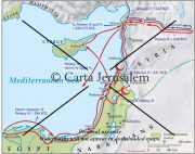
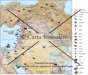
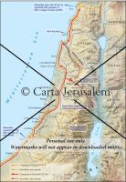
By: Carta Jerusalem Language: English Print size: 5.86x6.35 in (14.9x16.1 cm) 150 dpi - 582 kB For your personal use only Watermarks will not appear in downloaded maps. For commercial and any other application please Contact Us
$7.99
This revised and newly published book covers the historical geography of the Holy Land from 536 B.C. to A.D. 640. Part I deals in chronological order with the historical factors which have affected the map of the Holy Land during this period.
Antiochus IV Epiphanes’ harsh decrees had the effect of accelerating Jewish resistance to Greek customs rather than the intended opposite.
A set of 10 full-size sheets with 14 maps (28 x 40 in.) covering every aspect of JESUS AND THE APOSTLES. Specially designed as a teacher’s aid, these wall maps can be used in conjunction with our handbook, Jesus and the Apostles. which is free with this package. **** NEW *****
contact us
Reviews
There are no reviews yet.