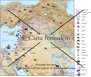
By: Carta Jerusalem Print size: 5.75x4.48 in (14.6x11.4 cm) 150 dpi - 511 kB For your personal use only Watermarks will not appear in downloaded maps. For commercial and any other application please Contact Us
$7.99
An Introductory Atlas & Comparative View Though centered in the southern Levant, the actual world of the Bible is much larger, stretching across the ancient Near East and filling the eastern Mediterranean Basin.
This revised and newly published book covers the historical geography of the Holy Land from 536 B.C. to A.D. 640. Part I deals in chronological order with the historical factors which have affected the map of the Holy Land during this period.
The contents of the Bible are so closely related to the lands or cities in which the recorded events took place, and in which the documents themselves were written, that it helps greatly to know something about those lands and cities.
contact us
Reviews
There are no reviews yet.