Shopping Cart

Illustrated Wall Maps Of The Bible
By: Carta
A set of full-size sheets of 12 maps and plans covering the whole Bible epoch. Specially designed as a teacher’s aid, it can be used in conjunction with Atlas of the Bible which is free with this package.
Suitable for adults or children, it is an economical and attractive aid to bring the Bible to life.
Ideal for schools, Sunday schools, Bible classes in schools, seminaries, and colleges.Language: English
12 full-size sheets, 28 x40 in. (70 x100 cm)
Box size: 10 x14 in. (25 x35.5 cm)
Featuring:
Maps:
Culture and Commerce in the Ancient Near East
Ancient Near East in the Second Millennium B.C.
The Near East in the First Millennium B.C.
The Coming of the Israelites
The Kingdom of David and Solomon
The Kingdoms of Judah and Israel
Palestine in Graeco-Roman Times
Jesus in His Land
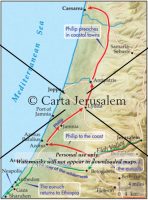
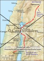
Journeys of the Apostles
The Spread of the Early Church
Palestine in the Time of the Old Testament
Palestine in the time of the New Testament
Free with this package:
Atlas of the Bible
Thirty full-color maps, 20 pages, illustrationsISBN: 965-220-493-5
Weight: 1.35 kg (3 pounds)
$45.00
More Products
-
The International Bible Atlas
$9.95 Add to cart16 color Holy Scripture maps This concise Bible Atlas traces the events and kingdoms from the 1st millennium BCE until Paul’s journey to Rome. The geography and history of the Ancient Near East and the lands of the Scriptures is clearly presented in sixteen easily-understood maps.
Reviews
There are no reviews yet.