Shopping Cart

Joab’s Census
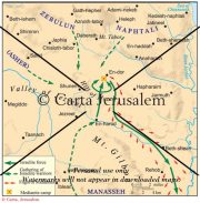
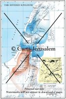
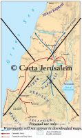
Joab's census The newly established kingdom of Israel is depicted in the census ordered by David. The territory covered represents all of the area directly under control of the monarchy in Jerusalem. Although the text of Joab’s itinerary (2 Sam 24:5–7) is badly preserved in spots, the general course of the census can be discerned. He began at Aroer on the traditional border with Moab (whenever Israel held the tableland). Then he progressed through the territory of Gad (in the western tableland itself according to Mesha’s inscription) to Jazer and on through Gilead. The next stage of the journey is obscured by a textual corruption, “tahtim hodshi,” but the best Greek version, albeit unclear, suggests that Bashan wasthe area visited. This makes sense since Joab went from there to Dan and on to “Jaan,” a spelling of Ijon with metathesis. Next they moved across Upper Galilee along the border with Sidon, past the “fortress of Tyre,” probably the Usu known from Egyptian and Assyrian inscriptions (Hellenistic Palaeotyrus, “Old Tyre”). By: Carta Jerusalem Print size: 2.82x5.14 in (7.2x13.1 cm) 150 dpi - 325 kB For your personal use only Watermarks will not appear in downloaded maps. For commercial and any other application please Contact Us
$7.99
Reviews
There are no reviews yet.