Shopping Cart

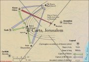
Map Of Jerusalem According To Theodisus
The writings of Theodosius, from the early fifth century, contained a guide to the visitor to the Holy Land, with special emphasis on Jerusalem and its Christian holy places. In his descriptions he referred to distances measured in double paces (a double pace = 4.86 feet [1.48 m]). There are many inaccuracies, such as the distance between the House of Caiaphas and Pilate's house (the Praetorium) given as about 100 meters (328 feet), as compared with a distance of 200 meters between the Church of the Holy Sepulcher and Mount Zion, which is the southern half of the city. It appears that these distances are not based on Theodosius' own experience but rather on information supplied by others. Despite these discrepancies, the map is extremely important for locating various sites in Jerusalem from the days of Theodosius.
By: Carta Jerusalem Language: English Print size: jerusalem, history, archaeology 150 dpi - 340 kB
For your personal use only Watermarks will not appear in downloaded maps. For commercial and any other application please Contact Us$7.99
More Products
-
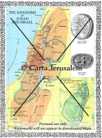
The Kingdoms Of Judah And Israel – Jerusalem Of The Old Testament
$7.99 Add to cartThe Kingdoms of Judah and Israel; Jerusalem of the Old Testament -
Archaeologists & Dates Of Excavations In The Old City And Its Environs
$7.99 Add to cartArchaeologists & Dates of Excavations in the Old City and its environs.
Reviews
There are no reviews yet.