Shopping Cart

Map Of The Mea She’arim Neighborhood
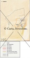
Map of the Mea She'arim neighborhood, the main part of which was completed by 1881. The quarter was planned by the architect Conrad Schick, who created a wall by building a line of attached houses along the perimeter of the area. The protected inner section served for the erection of public buildings, a park and a courtyard which was the center of communal activities. The adjacent neighborhoods of Batei Ungarin and Batei Neitin were built later, following a similar plan.
By: Carta Jerusalem Language: English Print size: 21.67 x 9.50 cm, 8.53 x 3.74 inches 150 dpi - 564 kB
For your personal use only Watermarks will not appear in downloaded maps. For commercial and any other application please Contact Us$7.99


Reviews
There are no reviews yet.