Shopping Cart

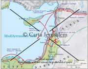
The Route Of Alexander The Great
By: Carta Jerusalem Language: English Print size: 7.89x4.67 in (20.0x11.8 cm) 150 Dpi - 1012 kB For your personal use only Watermarks will not appear in downloaded maps. For commercial and any other application please Contact Us
$7.99
More Products
-
The Holy Land – A Historical Geography From The Persian To The Arab Conquest 536B.C. To A.D.640
$25.00 Add to cartThis revised and newly published book covers the historical geography of the Holy Land from 536 B.C. to A.D. 640. Part I deals in chronological order with the historical factors which have affected the map of the Holy Land during this period.

Reviews
There are no reviews yet.