Shopping Cart

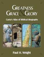
Philip, Peter And John To Samaria And The Coastal Plain
By: Carta Jerusalem Language: English Print size: 2.83x3.43 in (7.2x8.7 cm) 150 dpi - 274 kB For your personal use only Watermarks will not appear in downloaded maps. For commercial and any other application please Contact Us
$7.99
More Products
-
Greatness Grace & Glory
$50.00 Add to cartThis volume represents a new and necessary genre in the field of biblical studies. Greatness Grace & Glory is perhaps best described as a volume on applied or practical biblical historical geography. -
The Sacred Bridge
$120.00 Add to cartCarta’s Atlas of the Biblical World Documenting over 3,000 years of East Mediterranean history, this detailed volume is an up-to-date depiction of Biblical history and geography by way of the ancient sources with original texts and translations from native languages incorporated into the narrative of the Atlas.
Reviews
There are no reviews yet.