Online Store
Showing 145–160 of 722 results
-
Carta’s Bible Land QUIZ BOOK
$25.00 Add to cartThis highly educational Carta’s Bible Land Quiz Book is written, illustrated and produced in the Holy City of Jerusalem. This book is intended to be a challenging and pure-fun journey of discovery of the Bible. -
CARTA’S JERUSALEM STREET ATLAS
$14.95 Add to cartModern, user-friendly and up-to-date, Carta’s Jerusalem Street Atlas is part of Carta’s long established atlas series.
-
Carta’s Map Of Jerusalem
$10.95 Add to cartMap of the Old City, list of sites and institutions, general information, and index to street names. ****** UPDATED – 2014 *******
-
Carta’s Compact Bible Atlas – 2000 Jubilee Edition
$9.95 Add to cartThe contents of the Bible are so closely related to the lands or cities in which the recorded events took place, and in which the documents themselves were written, that it helps greatly to know something about those lands and cities.
-
Carta’s Comprehensive Bible Atlas On CD-ROM
$59.00 Add to cartCarta’s Comprehensive Bible Atlas on CD-ROM —– ONLY Windows XP / Vista / Windows 7 (32 bit) -
Carta’s Dictionary Of Economics, Statistics & Computers English-Hebrew / Hebrew-English
$24.00 Add to cartCarta’s Dictionary of Economics, Statistics & Computers English-Hebrew / Hebrew-English -

Carta’s Historical Atlas Of Jerusalem
$17.95 Add to cartAn Illustrated Survey This unique atlas presents the results of all the latest excavations and research.
-
Carta’s Illustrated Bible Atlas , With Historical Notes
$13.95 Add to cartFrom the Second Millennium B.C. to the First Century A.D., this compact and lavishly illustrated Bible Atlas, with its many maps, illuminates the biblical period and provides the reader with a visual background to the beauty of the Holy Scriptures. Now revised, it will serve another generation in gaining a better image of the Holy Writ.
-
Carta’s Illustrated Calendar Of Biblical Times 3000 B.C. – A.D. 150
$19.95 Add to cartThis colorful and instructive classroom aid follows all major regions, kingdoms and events, chronologically, of the ancient world.
-
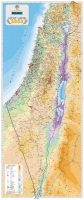
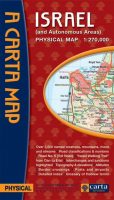
Carta’s Map Of Israel – Holy Land 2000
$20.00 Add to cartPhysical map of Israel, with a scale of 1:300,000. -
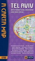
Carta’s Map Of Tel Aviv-Yafo
$10.95 Add to cartWith Ramat Gan, Givatayim and Bnei Brak. On back: list of sites and institutions, general information, and index to street names.
*** TEMPORARILY OUT OF STOCK *** -
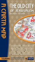
Carta’s Map Of The Old City Of Jerusalem
$8.95 Add to cartA clear, attractive, and useful map of the Old City of Jerusalem…
-
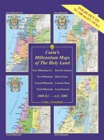
Carta’s Millennium Maps Of The Holy Land – 1000 B.C. – A.D. 2000
$19.95 Add to cartA Wall Chart – Carta’s Millennium Maps of the Holyland portray the extent of territorial control of the Holy Land at the turn of four millennia.
-
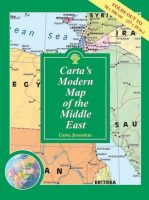
Carta’s Modern Map Of The Middle East – Wall Map
$19.95 Add to cartClearly presented colorful map of the Middle East showing major roads, railways and towns. – Alongside the map are vignettes of valuable information on each country in the Middle East. – Inset of world map showing area of the Middle East.
contact us